
Gartloch Gardens | Public Exhibition
Why?
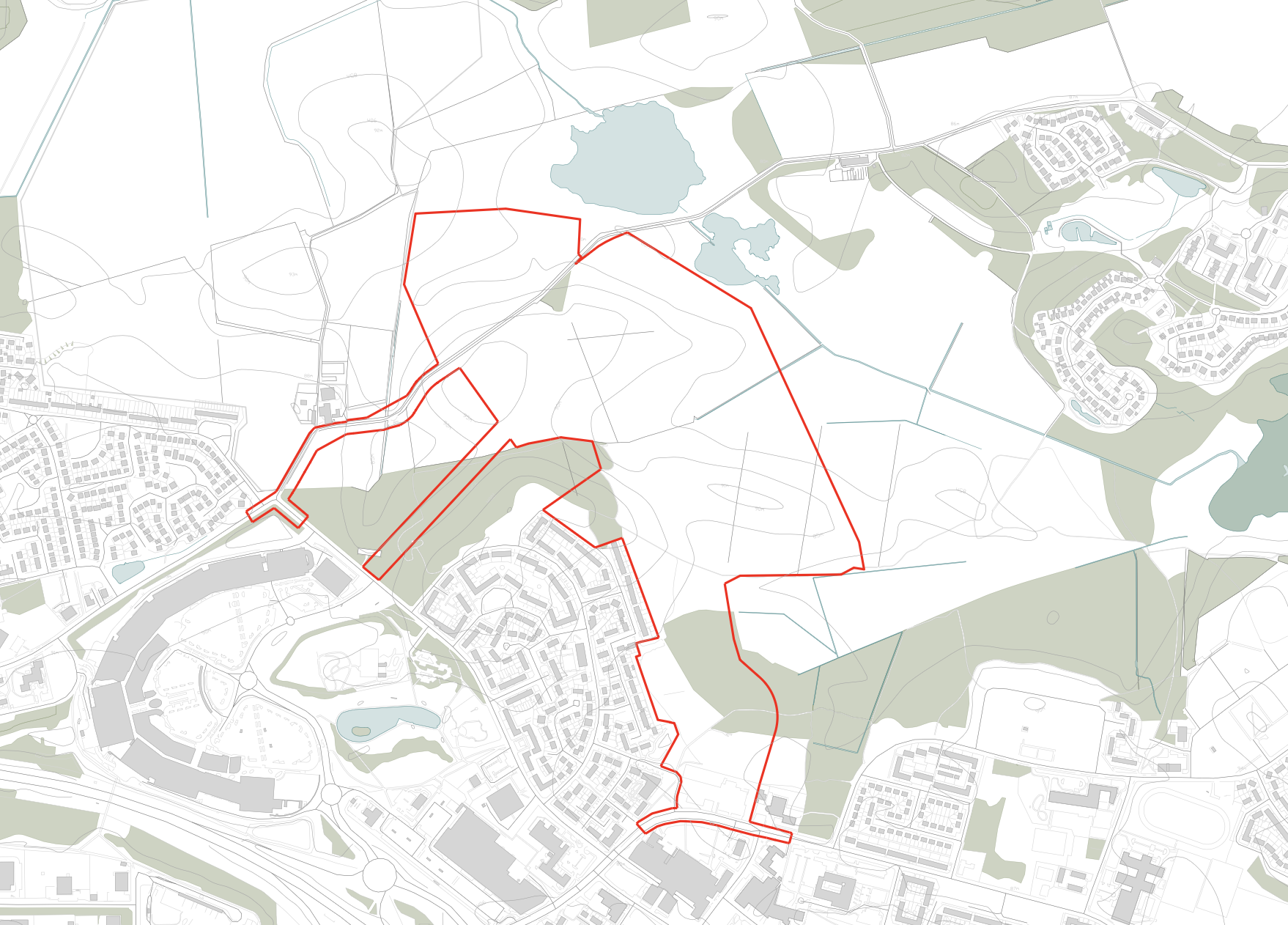
Apsley (Gartloch) Limited and McColl Holdings Limited are proposing the delivery of up to 800 units on a 49-hectare site allocated for residential development in Glasgow City Council’s adopted City Development Plan.
The team are developing exciting proposals to deliver a residential-led development on land at Gartloch Farm, neighbouring Easterhouse in Glasgow’s East End.
Where?
St Benedict’s Catholic Church on Westerhouse Road, Easterhouse, G34 9RP.
When?
Wednesday 22nd April 2026
Wednesday 24th June 2026
Between 3pm and 7pm
Background
The team are developing exciting proposals to deliver a residential-led development which would include a mixed-use neighbourhood centre, on land at Gartloch Farm, neighbouring Easterhouse in Glasgow’s East End. Promoted by a joint venture between Apsley (Gartloch) Limited and McColl Holdings Limited, the development team will progress the delivery of development on a 49-hectare site allocated for residential development in Glasgow City Council’s adopted City Development Plan.
A landscape-led development, it will also improve access to the Seven Lochs Wetland Park, Scotland’s largest urban heritage and nature park, responding to the site’s landscape and natural features.
As part of the proposals, there will be potential for local retail and community facilities to meet residents’ needs and complement existing nearby facilities at Glasgow Fort.
Regenerating the site will help Glasgow address its 2023 housing emergency and deliver significant economic benefits. It will create not only new, much-needed homes, but also construction jobs and, once operational, employment. Encompassing new housing and commercial use, the allocated development will foster a strong sense of community, supported by an improved network of formal and informal green spaces that bring people together, including allotments.
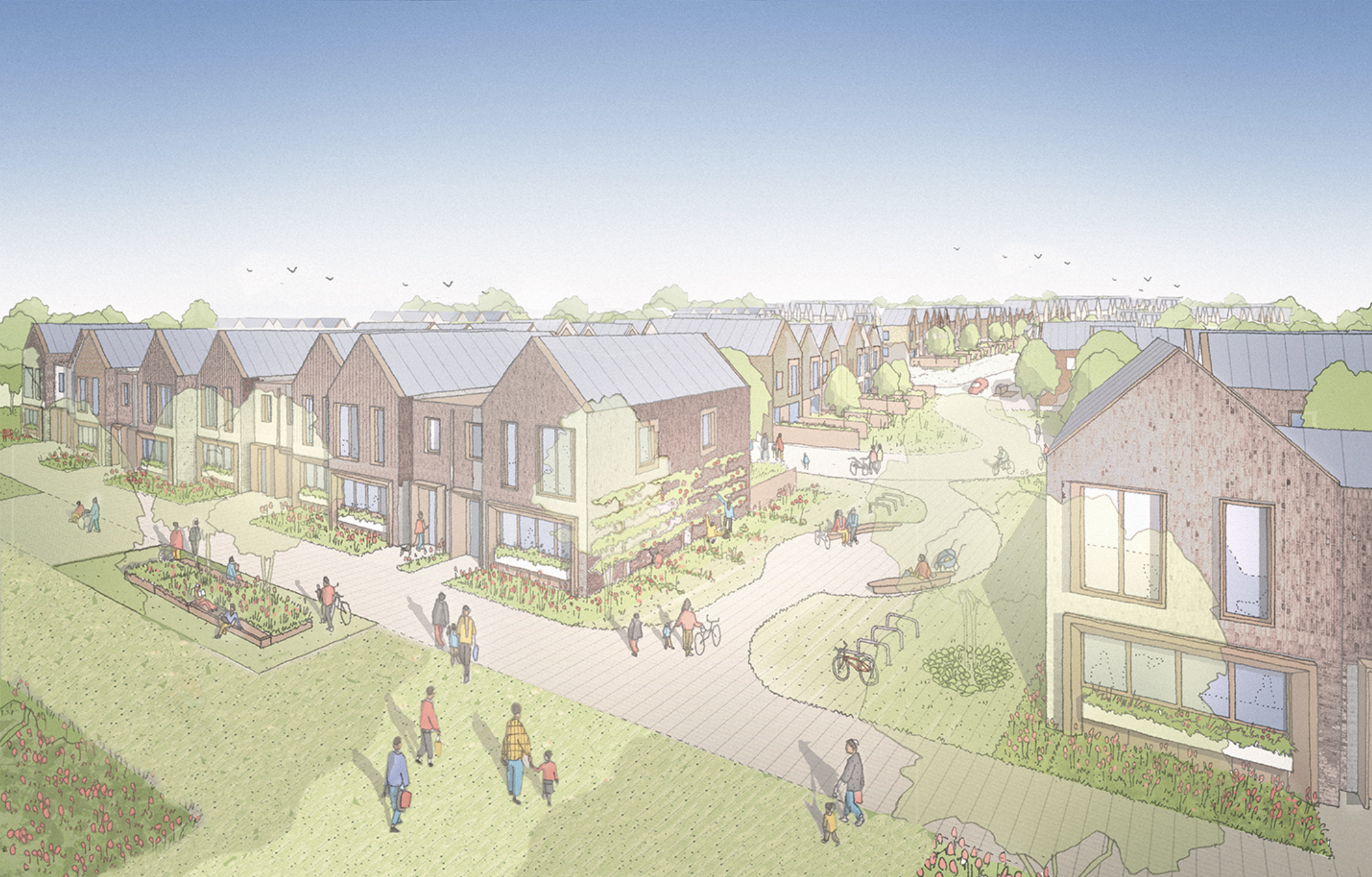
A network of accessible routes will prioritise walking and cycling, creating safe and attractive connections throughout the landscape. The design is also sympathetic to transport requirements and links within the area ensuring the delivery of increased active travel in combination with road network upgrades.
Consultation
A Proposal of Application Notice (26/00446/PAN) has been submitted to Glasgow City Council and other key stakeholders. This signifies the formal notice of intent to submit an application for Planning Permission in Principle (PPiP) following a minimum 12-week period of consultation.
This period of pre-application consultation comprised of two public consultation events, which were held on 22nd April and 24th June at St Benedict’s Catholic Church on Westerhouse Road, Easterhouse, G34 9RP. Between 3 pm and 7 pm.
The feedback window has now closed.
The exhibition boards from Event 2 are available to download below.
Please note that comments submitted at this stage are not representations to Glasgow City Council. There will be an opportunity to make representations to Glasgow City Council once a planning application is made.
For further information:
Please contact us on:
0131 202 3259
hello@gartlochgardens.com
Orbit Communications, 42 Charlotte Square, Edinburgh, EH2 4HQ
Fill out the form below to register for further information.
FAQs - Event 1
Topic 1: General
1. Is this public land, and what loss is given to the removal of the countryside?
The land is predominantly in the private ownership of Apsley (Gartloch) Limited and McColl Holdings Limited. There are parts within the red line boundary where the Glasgow City Council are the landowner, albeit these are limited to areas along Gartloch Road and Westerhouse Road.
2. What is being proposed?
The key elements of the Proposed Development are summarised as follows:
• up to 800 residential units across a mix of tenures;
• up to 500m2 of commercial floorspace (Class 1A, Class 3 and/or Class 10);
• a minimum of two new vehicular access points;
• internal road and pedestrian network;
• landscaping;
• SuDS;
• open space; and
• biodiversity enhancement measures.
The precise mix, density and layout will be based upon the comprehensive masterplanning process currently underway.
A north-south road will be provided through the site, connecting Westerhouse Road and Gartloch Road.
3. How will you use the feedback today?
Feedback will be open until 10 July; collated feedback from both events will be reviewed and total responses issued following the consultation exercise.
4. What is the history of the site?
The Site is currently vacant greenfield land with a historic agricultural use. The site has not been farmed at all since 1982.
In addition, two mineshafts and a well were indicated to be present. This suggests that mineral extraction has taken place beneath the Site, at least to some extent.
5. How have you informed the community?
We have been liaising with both elected representatives and community groups. The team organised a flyer drop to over 900 properties; a statutory notice has appeared in the Glasgow Times; and we have sent digital copies of our materials to stakeholders, inviting them to share them with their followers. We also have a dedicated project phone line and email address, and remain available to answer questions raised.
Topic 2: Economic
6. What is the overall benefit to residents and the City of Glasgow, and is there any consideration to social housing?
The proposals will deliver the development of much-needed housing, actively advancing key national ambitions while increasing the pipeline to address the ongoing challenges posed by the national and locally declared housing emergency.
– The proposed housing will provide a choice for prospective home owners and contribute to reducing pressure on housing affordability by bringing demand and supply into better balance.
– The proposals will result in additional population, which will benefit local businesses through the increase in footfall and new expenditures into Easterhouse Town Centre and the surrounding area.
– The proposals will create construction employment during the construction period. • The proposals will create operational jobs for local residents through the delivery of flexible commercial space.
– The proposals will raise revenue through both council tax and business rates receipts.
– The variety of new public and open spaces will be delivered, enhancing access to the site and the wider landscape it sits within. This will undoubtedly strengthen accessibility to the Seven Lochs Wetland Park.
Glasgow City Council’s planning policy does not require affordable housing to be delivered on mainstream housing sites in Glasgow. Glasgow has recently published its proposed City Development Plan 2, which maintains that no affordable housing contribution is required for housing sites in the city.
Notwithstanding this, a range of tenures of housing is currently being considered on-site. The final tenure mix will be determined by market demand at the detailed planning stage.
Topic 3: Planning
7. Are proposals based on earlier planning frameworks dating from around 2013, and if so, what updated assessments have been undertaken?
Planning permission in principle for a residential development on-site was approved, subject to the conclusion of a Section 75 legal agreement at the Planning Committee in 2009. While the Proposed Development draws on this previous application for background information, all technical assessments are being updated to reflect changes in site characteristics, the nature of development in the area, and local and national planning policies.
Topic 4: Infrastructure and Services
8. Can local roads cope with the development?
Gartloch Road is already very busy. We will be conducting a full review of road capacity and the potential impacts of the proposed development on the local roads’ infrastructure within the EIA Report. If any negative impacts are identified, appropriate mitigation will be proposed.
The development will deliver improvements to Gartloch Road, benefiting local road safety.
9. What improvements to local roads and movement are proposed in the area?
The development includes a new north-south route through the site, providing a connection from Gartloch Road to Westerhouse Road.
The development aims to prioritise active travel through the site. Several active travel links to the south and west of the site will also be developed to support active travel to key services and to allow existing area residents to access the site and the wider 7 Lochs Park.
The development will also be designed to support the extension of bus routes into the site.
10. Do schools and local GPs have capacity?
We are conducting Health Impact and Education Impact Assessments to assess local capacity for these key services. These reports will be submitted as part of the planning application.
If any capacity concerns are identified, developer contributions will be agreed with the Council via a legal agreement to support improvements to these services.
We are also currently discussing GP capacity with the local health board. The neighbourhood centre within the development includes provision for Class 10, which means a health centre could be provided on-site if required.
11. What infrastructure assessments have been undertaken, particularly in relation to school capacity, traffic and local services?
The proposed scope of the Transport Assessment has been submitted to the Council to ensure agreement on the assessments required to support the application. At present, several traffic counts and surveys are proposed to inform our assessments.
An Education Impact Assessment and Health Impact Assessment will also be submitted alongside the forthcoming PPP application. These will fully assess the potential impacts of the Proposed Development on these services and outline any proposed mitigation measures (e.g., developer contributions to school extensions, if required).
Further discussions will be held with Glasgow City Council as part of the pre-application process.
The description of the Proposed Development includes Class 10 uses. This means services such as a nursery or GP could be supported on-site within the potential neighbourhood centre if required.
Topic 5: Ecology and the Environment
12. What ecology surveys have been done/will be done to support the proposals?
Wild Surveys is currently undertaking a full suite of ecological surveys to understand the on-site ecology. These surveys include:
– Bird surveys
– Water Vole surveys
– Bat surveys
– National Vegetation Classification surveys
– Other protected species surveys
The EIA Report will set out all these findings and outline any proposed mitigation.
13. What ecological baseline surveys have been completed, including breeding bird and protected species assessments?
A range of ecological surveys have been completed on-site since the 2007 application.
As part of the current proposals, an ecological constraints survey was carried out to inform the EIA Scoping Report, which will agree the parameters of the forthcoming Environmental Impact Assessment (EIA) to be submitted in support of the applications. The scope of ecology surveys will be agreed with Glasgow City Council, in consultation with NatureScot, through the EIA scoping process. These will include habitat and NVC surveys, bird surveys, and protected species surveys such as great crested newt surveys and water vole surveys.
14. How has the proximity to Bishop Loch SSSI influenced site selection and development scale?
The site has been selected to ensure it is outside the SSSI boundary. Through an iterative design process, the Proposed Development will evolve to avoid/minimise impacts on the SSSI. The EIA Report will consider the potential for impacts on the SSSI within the LVIA, Ecology and Hydrology, Flooding and Peat.
15. Is an EIA going to be provided with this application?
Yes. An EIA Report will be submitted alongside the PPP application. The scope of this report is currently being agreed upon with GCC.
The chapters proposed for inclusion at present are:
– Landscape and Visual Impact Assessment
– Ecology & Ornithology
– Hydrology, flooding and peat
– Drainage and the water environment
– Geology and Ground Conditions
– Noise and vibrations
– Air quality
– Transport and travel
– Archaeology and cultural heritage
Topic 6: Development details
16. Will there be any affordable housing on-site?
Why is the site not delivering 25% Glasgow City Council’s planning policy does not require affordable housing to be delivered on mainstream housing sites in Glasgow. Glasgow has recently published its proposed City Development Plan 2, which maintains that no affordable housing contribution is required for housing sites in the city.
Notwithstanding this, a range of housing tenures is currently being considered onsite. The final tenure mix will be determined by market demand at the detailed planning stage.
17. What types of housing are proposed?
While the final mix and tenure of housing will be confirmed at the detailed design stage, the development aims to deliver a mix of housing types, sizes and tenures to support a diverse and inclusive community.
18. How is women’s safety being addressed within the proposals?
The design of the development has considered the safety of those moving through the site from the outset. The new homes will provide overlooking and passive surveillance of key routes, improving the sense of safety in the area.
Topic 7: Construction impacts
19. What will the construction impacts of the proposed development be?
The EIA Report will fully assess the potential impacts of the construction phase, including landscape impacts and traffic impacts.
Construction traffic will be effectively managed through a Construction Traffic Management Plan. In line with best practice, a road condition survey will be conducted before and after construction, and any damage to local roads resulting from the development will be repaired.
Topic 8: Principle
20. This area is within the greenbelt. Developing here would be overdevelopment.
The site is allocated for a housing development in the Glasgow City Council’s City Development Plan.
The site is not currently designated as a greenbelt.
21. Loss of green space currently used by the community
While it is acknowledged that the site currently provides informal green spaces used by the local community, the development will deliver new high-quality green spaces which will be accessible to both existing and future residents.
Topic 9: Heritage
22. How is the heritage of the local area being considered within design proposals?
Archaeological walkovers have been undertaken to assess the potential for buried archaeology. The potential for heritage impacts will be fully assessed within the EIA Report, with mitigation recommended if required.
FAQs - Post-Event 1
- What feedback was received from Event 1 and how was this considered at Event 2?
The first consultation event was well attended, with over 70 people viewing the consultation material on the day. We received many positive and constructive comments at the first consultation. We also registered several concerns and considered challenges on matters that are important to the community. These are summarised below:
- Infrastructure capacity and necessary upgrades
- Impacts on greenspaces, ecology and wildlife
- Types of housing to be delivered
- Safety and active travel accessibility
- Construction Impacts
- Heritage considerations incorporated into design.
These themes are identified on the first board displayed at Event 2. The design of the development was progressed and information shared at Event 2 which was informed by these key themes, with information responding to these queries integrated across the information boards. The emphasis on placemaking, landscaping, local heritage and active travel responded to the key themes raised at the first event.
In addition, the FAQs below are available to answer some of the more specific questions raised at Event 1. The FAQs have now been updated to reflect feedback received at Event 2.
A pre-application consultation (PAC) report will be submitted alongside the application which will detail the comments made by members of the public at both events and how these have been considered within the submission.
- What is Planning Permission in Principle?
Planning Permission in Principle (PPP) is a type of planning application which seeks approval for the general principle of a development before submitting detailed plans. It’s a way to test whether a proposed development is acceptable in theory, without committing to specifics like design or layout.
Planning Permission in Principle is not a detailed planning application. If PPP is granted, a further application called Approval of Matters Specified in Conditions (AMSC) would be submitted to agree in the detailed aspects like design, access and landscaping.
- When will the survey data gathered be available for the public to view?
The project team is currently undertaking a wide range of site surveys and environmental assessments to inform the Environmental Impact Assessment and PPP submission. This information will be available to the public following the submission of the application to Glasgow City Council in Autumn 2026.
Survey work is ongoing and data and environmental information cannot be shared prior to submission.
- Is this public land, and what loss is given to the removal of the countryside?
The land is predominantly within the private ownership of Apsley (Gartloch) Limited and McColl Holdings Limited. There are parts within the red line boundary where Glasgow City Council are the landowner albeit these are limited to areas along Gartloch Road and Westerhouse Road.
- What is the overall benefit to residents and the City of Glasgow, and
The proposals will deliver the development of much needed housing which will actively deliver on key national ambitions while also delivering an increased pipeline of housing to address the ongoing challenges faced through the national and locally declared housing emergency.
- The proposed housing will provide choice for prospective home owners and contribute to reducing pressure on housing affordability by bringing demand and supply into better balance.
- The proposals will result in additional population which will benefit local businesses through the increase in footfall and new expenditures into Easterhouse Town Centre and surrounding area.
- The proposals will create construction employment during the construction period. • The proposals will create operational jobs for local residents through the delivery of flexible commercial space.
- The proposals will raise revenue through both council tax and business rates receipts.
- The variety of new public and open spaces will be delivered enhancing access to the site and wider landscape it sits within. This will undoubtedly strengthen accessibility to the Seven Lochs Wetland Park.
- Is there any consideration to social housing onsite?
Glasgow City Council planning policy does not require the delivery of affordable housing on mainstream housing sites in Glasgow. Glasgow have recently published their proposed plan for City Development Plan 2 which maintains that no affordable housing contribution is required for housing sites in Glasgow.
Notwithstanding this, a range of tenures of housing are currently being considered onsite. The final tenure mix will be determined by market demand at the detailed planning stage.
- Are proposals based on earlier planning frameworks dating from around 2013, and if so, what updated assessments have been undertaken?
Planning permission in principle for a residential development on-site was approved, subject to the conclusion of a Section 75 legal agreement at the Planning Committee in 2009. While the Proposed Development draws on this previous application for background information, all technical assessments are being updated to take into account changes in site characteristics, the nature of development in the area, and local and national planning policies.
- What ecological baseline surveys have been completed, including breeding bird and protected species assessments?
A range of ecological surveys have been completed on-site.
As part of the current proposals, an ecological constraints survey was carried out to inform the EIA Scoping Report, which helped to agree the parameters of the forthcoming Environmental Impact Assessment (EIA) to be submitted in support of the application.
A full suite of ecology surveys are being undertaken, the scope of which have been agreed with Glasgow City Council, in consultation with NatureScot, through the EIA scoping process. These include habitat and NVC surveys, bird surveys, and protected species surveys such as great crested newt surveys and water vole surveys.
The EIA will provide full details on the assessment of ecology, protected species, and the potential for effects on the Bishop Loch SSSI.
9. How has the proximity to Bishop Loch SSSI influenced site selection and development scale?
The site has been selected to ensure it is outside the SSSI boundary. Through an iterative design process, the Proposed Development will evolve to avoid/minimise impacts on the SSSI. The EIA Report will consider the potential for impacts on the SSSI within the LVIA, Ecology and Hydrology, Flooding and Peat chapters.
10. What infrastructure assessments have been undertaken, particularly in relation to school capacity, traffic and local services?
The proposed scope of the Transport Assessment has been submitted to the Council to ensure agreement on the assessments required to support the application. At present, several traffic counts and surveys are proposed to inform our assessments.
An Education Impact Assessment and Health Impact Assessment will also be submitted alongside the forthcoming PPP application. These will fully assess the potential impacts of the Proposed Development on these services and outline any proposed mitigation measures (e.g., developer contributions to school extensions, if required). Further discussions will be held with Glasgow City Council as part of the pre-application process.
The description of the Proposed Development includes Class 10 uses. This means services such as a nursery or GP could be supported on-site within the potential neighbourhood centre if required.
11. How has cumulative development in the wider area been considered in current proposals?
Committed development and infrastructure will be included within the baseline of the technical assessments undertaken to ensure cumulative impacts are properly considered.
The requirement for any cumulative assessment within the EIA will be agreed with the planning authority through consultation.
- How have you informed the local community?
We have been liaising with both elected representatives and community groups. The team organised a flyer drop to over 900 properties; a statutory notice has appeared in the Glasgow Times; and we have sent digital copies of our materials to stakeholders, inviting them to share them with their followers.
We also have a dedicated project phone line and email address and remain available to answer questions raised.
- What is the history of the site? Did this not used to be farmland?
The Site is currently vacant greenfield land with a historic agricultural use. The site has not been farmed at all since 1982.
In addition, two mineshafts and a well were indicated to be present. This suggests that mineral extraction has taken place beneath the Site, at least to some extent.
- What is being proposed?
The key elements of the Proposed Development are summarised as follows:
- up to 800 residential units across a mix of tenures;
- up to 500m2 of commercial floorspace (Class 1A, Class 3 and/or Class 10);
- a minimum of two new vehicular access points;
- internal road and pedestrian network;
- landscaping;
- SuDS;
- open space; and
- biodiversity enhancement measures.
The precise mix, density and layout will be based upon the comprehensive masterplanning process currently underway.
A north-south road will be provided through the site, connecting Westerhouse Road and Gartloch Road.
- Is an EIA going to be provided with this application?
Yes. An EIA Report will be submitted alongside the PPP application. The scope of this report has been agreed with Glasgow City Council in consultation with a number of statutory bodies including SEPA and NatureScot.
The chapters proposed for inclusion at present are:
- Landscape and Visual Impact Assessment
- Ecology & Ornithology
- Hydrology, flooding and peat
- Drainage and the water environment
- Geology and Ground Conditions
- Transport and travel
Archaeology and Heritage, Noise and Vibrations and Air Quality have been scoped out of the EIA by GCC. These topics will still be assessed by standalone reports within the planning submission.
- What heritage and archaeological assessments have been undertaken to support the planning application?
Prior to Event 1, a desk based assessment of heritage and archaeological was undertaken to support the EIA Scoping Report. Following Event 1, a heritage and archaeological walkover survey was completed which will inform the assessment of heritage and archaeology within the planning submission. A Cultural Heritage Impact Assessment Report will be submitted as part of the planning application which will outline if any further assessments are required.
Historic Environment Scotland (HES) and West of Scotland Archaeology Society (WOSAS) have been formally consulted by GCC on the EIA Scoping Report. They will be formally consulted again at the point of planning submission. Both parties were content with the scope and methodology of the assessments proposed.
- What assessments have been undertaken regarding existing drainage capacity and system resilience and how is drainage and the water environment being considered within the submission?
Assessments of existing drainage capacity/ infrastructure is currently being undertaken to inform the EIA. Previous recorded issues in the area are acknowledged. The proposed drainage strategy will be designed to ensure no adverse impacts on local infrastructure or the surrounding hydrological environment including the Bishop Loch SSSI. The drainage strategy proposed will accord with all relevant SEPA and GCC guidance.
Impacts on the water environment will be considered within the EIA. SEPA and Scottish Water have both been consulted through the EIA scoping process and will continue to be consulted as the application moves towards submission stage.
As this application is for Planning Permission in Principle, further information on the detailed drainage strategy will be developed and agreed with the Council at the detailed design stage.
- How are cross boundary impacts (between Glasgow and North Lanarkshire) being considered?
North Lanarkshire have been consulted on the proposals through the EIA scoping process and will be a consultee when the planning application is submitted.
Assessments undertaken to support the planning submission will consider cross-boundary impacts including transport and landscape and visual effects. The study areas for the assessments undertaken have been defined based on the best practice guidelines and the professional judgement of the project team and is not directly influenced by the Glasgow/ North Lanarkshire boundary.
Leave Your Feedback
GARTLOCH GARDENS – PUBLIC CONSULTATION 1 – 22 APRIL 2026 (3-7 PM)
Feedback Questionnaire
Event: Wednesday 22nd April 2026 / Wednesday 24th June 2026 between 3 pm and 7 pm at St Benedict’s Catholic Church on Westerhouse Road, Easterhouse, G34 9RP
Feedback deadline for Event 2: 10 July 2026
Providing your feedback
You can respond to this consultation by:
- Completing a feedback form at the event
- Completing a feedback questionnaire online here
- Completing a feedback form and returning it to: Orbit Communications, 42 Charlotte Square, Edinburgh, EH2 4HQ
- Emailing us at: hello@gartlochgardens.com